GPS Units - Accessories
Autopilots - Marine
Cameras
Chart Plotters
Communications
Dash Cameras
EPIRBs & PLBs
Fitness, Sports & Golf
Fishfinders
Garmin Fitness
GPS-Fishfinders
GPS-GMRS Radios
Maps & Software
Hiking & Handheld GPS
Wearables
Laptop & Tablet GPS
Marine Electronics
Motorcycle Units
Network Systems
Off Road GPS
Radars
Safety Equipment
Starlink Mounts
Stereos & Speakers
Top Choice Products
Tracking Devices
Trolling Motors
Truck & RV GPS
VHF Radios
Accessories
Garmin Accessories
Marine Accessories
Transducers
Actisense
B&G
BilgeBuddy
Blue Sea Systems
C-Map Charts
CMOR Charts
Flir Thermal Imaging
Fujinon Marine Binoculars
Furuno Marine Electronics
Fusion Stereos
Garmin GPS
Icom Marine Radios
JL Audio
KVH Satellite TV
Lowrance Electronics
Lumishore LED Lights
Magellan GPS Systems
Navionics Charts
Ocean Signal
Pelican Lights
Poly Planar Stereos
Raymarine Electronics
Scanstrut
Seaview Mounts
Shakespeare
Simrad Marine
Sionyx
Si-Tex Marine Electronics
Standard Horizon
Superior Life Saving Life Rafts
USGlobalSat
Veratron
Vesper Marine
GPS = Global Positioning System
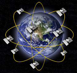 The Global Positioning System is a constellation of satellites that orbit the earth twice a day, transmitting precise time and position (latitude, longitude and altitude) information. With a GPS receiver, users can determine their location anywhere on the Earth. Position and navigation information is vital to a broad range of professional and personal activities, including hiking, hunting, camping, boating, surveying, aviation, national defense, vehicle tracking, navigation and more.
The complete system consists of 24 satellites orbiting about 12,000 miles above the Earth, and five ground stations to monitor and manage the satellite constellation. These satellites provide 24-hour-a-day coverage for both two-and three- dimensional positioning anywhere on Earth.
Development of the $10 billion GPS satellite navigation system was begun in the 1970s by the US Department of Defense, which continues to manage the system, to provide continuous, worldwide positioning and navigation data to US military forces around the globe. However, GPS has an even broader civilian, commercial application. To meet these needs, GPS offers two levels of service, one for civilian access and the second encrypted for exclusive military use. The GPS signals are available to an unlimited number of users simultaneously, and there is no charge for using the GPS Satellites either.
How Does GPS Work?
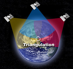 The basis of GPS technology is precise time and position information. Using atomic clocks and location data, each satellite continuously broadcast the time and its position. A GPS receiver receives these signals, listening to three or more satellites at once, to determine the users position on earth.
By measuring the time interval between the transmission and the reception of a satellite signal, the GPS receiver calculates the user and each satellite. Using the distance measurements of at least three satellites in an algorithm computation, the GPS receiver arrives at an accurate position fix. Information must be received from three satellites in order to obtain two-dimensional fixes(latitude and longitude) known as triangulation, and four satellites are required for three-dimensional positioning (latitude, longitude and altitude).
Under normal conditions, the GPS signal will provide a civilian user an accuracy of better than 15 meters (50 feet). However, using a technique called differential GPS (DGPS), the user can increase the overall accuracy of the GPS receiver to approximately 1-3 meters. With DGPS, one GPS receiver unit is placed in a known location and the position information from that receiver is used to calculate correction in the position data transmitted to other GPS receivers in the area. The resulting real-time accuracy is in the 10 foot range. Sub-meter accuracy can be obtained by using DGPS and post-processing calculations in static positioning.
WAAS GPS
WAAS stands for Wide Area Augmentation System, which is a system of satellites and ground stations that provide GPS signal corrections, giving you even better position accuracy. A WAAS-capable receiver can give you a position accuracy of better than three meters, 95 percent of the time. And you don't have to purchase additional receiving equipment or pay service fees to utilize WAAS.
The origins of WAAS
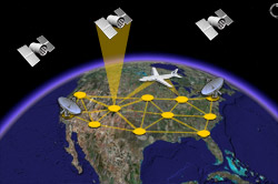 The Federal Aviation Administration (FAA) and the Department of Transportation are developing the WAAS program for use in precision flight approaches. Currently, GPS alone does not meet the FAA's navigation requirements for accuracy, integrity and availability. WAAS corrects for GPS signal errors caused by ionospheric disturbances, timing and satellite orbit errors and provides vital integrity information regarding the health of each GPS satellite. Although WAAS has not yet been approved for aviation, the system is available for civilian use, such as for boaters and recreational GPS users.
How it Works
WAAS consists of approximately 25 ground reference stations positioned across the United States that monitor GPS satellite data. Two master stations, located on either coast, collect data from the reference stations and create a GPS correction message. This correction accounts for GPS satellite orbit and clock drift plus signal delays caused by the atmosphere and ionosphere. The corrected differential message is then broadcast through one of two geostationary satellites, or satellites with a fixed position over the equator. The information is compatible with the basic GPS signal structure, which means any WAAS-enabled GPS receiver can read the signal.
Who benefits from WAAS?
Currently, WAAS satellite coverage is only available in North America. There are no ground reference stations in South America, so even though GPS users there can receive WAAS, the signal has not been corrected and thus would not improve the accuracy of their unit. For some users in the U.S., the position of the satellites over the equator makes it difficult to receive the signals when trees or mountains obstruct the view of the horizon. WAAS signal reception is ideal for open land and marine applications. WAAS provides extended coverage both inland and offshore compared to the land-based DGPS (differential GPS) system. Another benefit of WAAS is that it does not require additional receiving equipment while DGPS does.
Other governments are developing similar satellite-based differential systems. In Asia, it's the Japanese Multi-Functional Satellite Augmentation System (MSAS), while Europe has the Euro Geostationary Navigation Overlay Service (EGNOS). Eventually, GPS users around the world will have access to precise position data using these and other compatible systems.
It just keeps getting better
| 100 meters: | Accuracy of the original GPS system, which was subject to accuracy degradation under the government-imposed Selective Availability (SA) program. | 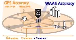 |
| 15 meters: | Typical GPS position accuracy without SA. | |
| 3-5 meters: | Typical differential GPS (DGPS) position accuracy. | |
| < 3 meters: | Typical WAAS position accuracy. |
Who Uses GPS?
  |
  |
GPS receivers provide positioning, velocity and navigation information for a variety of markets and purposes. Anyone who needs to know the precise time or the exact location of people or objects will benefit from GPS. In turn, this information can be used in charting and mapping, plotting a course, navigating from point to point, tracking vehicle movement, locating previously identified sites or any number of similar functions. Marine GPS receivers are providing to be invaluable aids in both recreational and commercial boating and sailing. Land-based professions from survey to exploration employ GPS to provide vital positioning and location information. Surveyors, natural resource managers, wildlife managers, geologist, geographers, mappers, forestry managers, search and rescue teams, public safety professionals, archaeologists, utility managers, and oil, gas and mineral explorers are just some of the people taking advantage of GPS. Other applications may include avionics and other outdoor recreational activities such as backpacking, camping, hiking, mountain biking and snowmobiling.


