CMOR Chart for Bahamas for Navico

Free 2-Day Shipping!

CMOR Chart for Bahamas for Navico

The CMOR Bahamas chart for Navico displays is a pre-loaded microSD/SD Card with some of the best fishing, diving, and deep dropping spots in the islands with coverage from Bimini, Cat Cay, Riding Rocks, Little Egg Harbour Island and More! The CMOR Bahamas chart includes privately mapped data of The Bahamas with unparalleled detail.
  • SKUCOBAHA001S
  • MAN#BAHA001S
  • ID#: 7045
(Rating 92)
Our Price:
$1,000.00
Availability: 
In Stock
Shipping:
Free 2-Day Shipping!
Condition:
Brand New

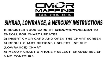
Highly Detailed Charts for Your Navico Chartplotter!

The Bahamas 3D Relief Shading Card coverage includes:

  • Bimini
  • Cat Cay
  • Riding Rocks
  • Isaacs The Channel
  • Nassau
  • Bullock Harbour
  • Great Stirrup Cay
  • Grand Bahama
  • Lucaya
  • Freeport
  • West End
  • Memory Rock
  • White Sands
  • Matinilla
  • Walkers Cay
  • Grand Cay
  • Strangers Cay
  • Abbaco
  • The Elbow
  • Marsh Harbour
  • Little Harbour Egg Island
  • Sandy Castaway
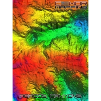
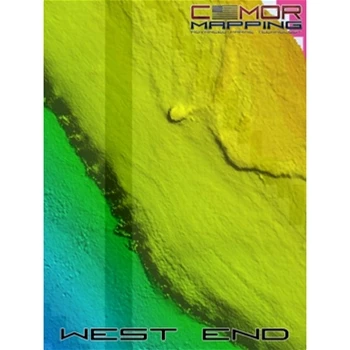
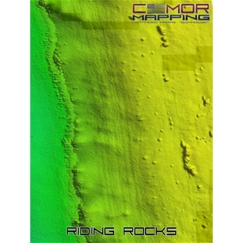
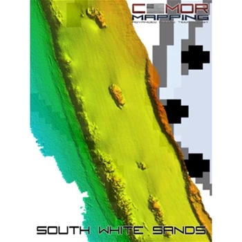
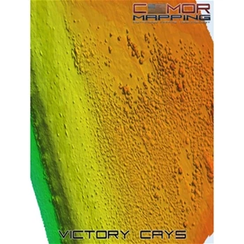
  • CMOR bathymetry is based exclusively on full-coverage surveys of the bottom with high-resolution echo sounding equipment. These maps are easy to read and interpret with depth being represented by color. Reds are the shallowest, purples and magentas the deepest. The CMOR Bahamas Chart includes privately mapped data of the Bahamas with unparalleled detail.

    The CMOR chart for Navico is compatible with a wide range of Navico products including:

    Lowrance

  • HDS Gen1 series
  • HDS Gen2 series (both keypad and touchscreen)
  • HDS Gen3 series
  • HDS Carbon
  • HDS Live
  • Elite HDI series
  • Elite CHIRP series
  • Elite Ti series
  • Elite FS series
  • Simrad

  • NSS
  • NSS evo3
  • NSS evo3S
  • NSE
  • NSO
  • NSO evo2
  • NSO evo3
  • NSX
  • GO XSE
  • GO XSR
  • CMOR Chart for Bahamas for Navico Box Contents
    Each CMOR Chart for Bahamas for Navico Comes with:
    • CMOR Chart on MicroSD Card in SD Card Adaptor
    CMOR Chart for Bahamas for Navico Key Features
    • Your vessel icon is overlaid on the CMOR data, showing you exactly where you are in relation to bottom features
    • All vector data available on your plotter — tides, nav aids, routes, waypoints, etc.
    • CMOR Mapping data is the result of methodical surveys with high-resolution echosounders
    • Depth is represented by color. Reds are the shallowest, purples and magentas the deepest
    • Your user data will still be accessible and will run on top of CMOR imagery