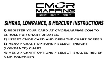
Highly Detailed Charts for Your Navico Chartplotter!
The South Florida CMOR Card Covers from Jensen Beach through Key West on the Atlantic Coast and features private data collection from 2020. CMOR maps provide resolution as sharp as 1 meter in shallow areas while also providing extreme detail in deeper waters.
CMOR bathymetry is based exclusively on full-coverage surveys of the bottom with high-resolution echo sounding equipment. These maps are easy to read and interprete with depth being represented by color. Reds are the shallowest, purples and magentas the deepest. The South Florida CMOR chart also includes NOAA charts 11465, 11466, 11467, and 11468 in the background.
The CMOR South Florida card includes continuous nearshore detail from Boynton Beach through North Miami, with depths ranging from 100ft to 400ft along the coastline. Features include coverage of Florida’s reef systems, artificial reefs and shipwrecks. Continuous nearshore detail from Alligator Light through Ocean Reef, with depths ranging from 50ft to 250/300ft and up to date scans of objects subject to movement such as wrecks, as well as newly sunken objects and vessels. Detail also includes nearshore and deep drop coverage throughout Key West, with continuing deep drop coverage through the upper keys.
Featured Spots:
- Tenneco Towers
- USS Spiegel Grove
- The Duane
- The Bibb
- Molasses Reef
- French Reef
- Pickles Reef
- Hillsboro Wrecks
South Florida Featured Areas include:
- Hollywood
- Fort Lauderdale
- Pompano
- Deerfield
- Boca Raton
- Boynton Beach
- Lake Worth
- West Palm
- Jupiter
- Hobe Sound
- Stuart
- Continuous deep drop and swordfish grounds from Stuart through Miami.
- And most importantly, all the unnamed reefs between the well-known areas!
Whether you’re fishing for swordfish, snowy grouper, snapper or other bottom fish species, CMOR maps will help you locate fish hanging out in even the best hiding spots.
Deep-drop locations:
- 12 miles offshore of Islamorada FL
- 15 miles offshore of Duck Key
- West Marathon Hump, 22 miles offshore of Duck Key
- 21 miles offshore of Duck Key
- 29 miles offshore of Marathon
- 10 miles offshore of Key West
- Continuous deep drop coverage from Key West to South Miami
The CMOR chart for Navico is compatible with a wide range of Navico products including:
Lowrance
- HDS Gen1 series
- HDS Gen2 series (both keypad and touchscreen)
- HDS Gen3 series
- HDS Carbon
- HDS Live
- Elite HDI series
- Elite CHIRP series
- Elite Ti series
- Elite FS series
Simrad
- NSS
- NSS evo3
- NSS evo3S
- NSE
- NSO
- NSO evo2
- NSO evo3
- NSX
- GO XSE
- GO XSR
- CMOR Chart on MicroSD Card in SD Card Adaptor
- Continuous nearshore expansion from Boynton Beach through North Miami, with depths ranging from 100ft to 400ft along the coastline
- Continuous nearshore expansion from Alligator Light through Ocean Reef, with depths ranging from 50ft to 250/300ft
- Strategic rescanning of objects subject to movement such as wrecks, as well as newly sunken objects and vessels
- Significant addition of nearshore and deep drop coverage throughout Key West, with continuing deep drop coverage through the upper keys
- Your user data will still be accessible and will run on top of CMOR imagery

Similar Products and Value Bundles
CMOR Chart for South Atlantic for Navico
- CONEFL002S
- MAN#NEFL002S
- ID#: 6251
in 2-3 Days
CMOR Mid Atlantic for Navico
- COMIDA001S
- MAN#MIDA001S
- ID#: 6567


